
Visit our main website at SoutheasternBound.net. We post history/travel every Monday, then photos/photo tips each Thursday. Please click the Follow button (below right) for updates on Southeastern Bound.
By Jim Byous

Oatman, Arizona was once the gateway to the promised land – California. Today it serves travelers and tourists searching for the past. It fills the bill.
It is legend. This stretch of Route 66 runs like a thread, winding through the hot desert hills, twisting, rising and dropping in the dry, rocky, near-depleted-gold-bearing mountains between Kingman and Oatman, Arizona. I have not seen it in the six decades of my life. I’ve always wanted to. Now I am.
My wife, Becky, aka “The Beckster,” rides shotgun as we leave our motel in Needles, California. It is just before the morning sun creeps over the horizon. Across the Colorado River, we can see Boundary Cone on the opposite side of the Arizona state line. It is already getting hot. Thank God for air-conditioned pickups. Our time is short, appointments in the Phoenix area dictate a “flyby” view of the town and route without a scheduled stop. Now that we live in the Southeast – on the other side of the continent – it is compulsory that we see the legend… the road and the town.

Boundary Cone peaks above the skyline beside the route from Needles, California to Oatman, Arizona. It is a sacred place to the Mojave Tribe and has been a landmark for travelers over the years. Below it are the row crops of the fertile Mojave Valley on the Arizona side of the state line.
I remember the stories told by my parents and grandparents of traveling to California in the years before I was born. “I don’t like threading the needle’s eye,” my grandfather, Mark Covey, would joke while telling of this road. “Don’t want to go back.” He didn’t.
In the 1940s he had crossed the snaking stretch of Route 66 in a cut-down 1931 Hupmobile. A makeshift “dog house” replaced the back seat and trunk, an alteration designed to carry and cover bored, sleeping kids and grandkids during the long, sun-baked and dangerous trip from Eastern Oklahoma. Over the previous two decades he and others, who are now called “Steinbeck’s Okies,” journeyed to join my parents who were working in the bean fields of California’s Central Valley.

This Arkansas family rides in a truck with a “dog house” on the back. Mark Covey’s Hupmobile doghouse was much smaller during its trek across Arizona’s southwestern desert. Library of Congress photo by Dorothea Lang.
But, the gateway to the promised land lay along the twisted, narrow highway through the minaret-shaped rhyolite plugs of the Needles region and the near-abandoned gold town of Oatman, a town that was saved from extinction by supplying the needs of the traffic on Route 66. As in my grandfather’s time, today the town survives by selling food, drink, and trinkets to travelers and tourists who follow their dreams. In times before they searched for a new life. Today they search for the past… just as we are.
Every year in my childhood our summer vacation was in Eastern Oklahoma the place our family called “home.” We rolled through the Needles area in the warm season, in the pre-auto-air-conditioner days. On those occasions my brother and I could be seen passing by, holding wet washcloths out of the car window in an attempt to grab a fleeting ration of cool for our faces. One of our primitive swipes at cooling took place in Needles during an 11 P.M. passing in 1960. The outside temperature measured 109 degrees Fahrenheit. Somewhere along the route the cloth slipped from my brother’s hand and swirled off into the desert sticking to a distant, dry tumbleweed. Mom was not amused. Neither was I. I had to share my cloth.
Route 66 had changed by that time, bypassing Oatman and diving straight into the Mojave Desert on the way to Kingman. Each year, passing the turnoff to the “needle’s eye” my mother would laugh and quote her father’s rebuke of the area. It was an annual ritual in oral tradition.

Entering Arizona’s Black Mountains a short distance from Oatman on the Old Route 66.
Now, as we approach Oatman the first rays of sunlight touch the surrounding hilltops. It slowly creeps downward, crawling across the rocks, rooftops, and road as the town fills our windshield. The hamlet is quiet, the kind of quiet that seeps into your head the way heat soaks into a Mojave rock formation – slowly and intensely. The sound of our motor reminds us that we have not lost our hearing.
Nothing stirs; not bird nor dog nor human. It’s eerie, but oddly inviting. It feels lonely like the loneliness heard in the howl of a wolf on a dark wilderness night. The smell of dust and sage hangs in the air as the temperature rises. The occasional scents of burro dung and automobile oil waft upward from the roadway through the truck’s ventilation system.

Oatman from the north at sunrise. The town is quiet, still sleeping. No-one is stirring.
The Beckster and I grab our cameras and click away, some from the truck, but other shots require stopping to compose and capture. Time is short. We must hurry. I hate it. I love this place. I can feel the history soaking up out the ground and from the wooden framed buildings that surround us. This place is filled with hidden stories, hidden secrets.
This tiny mining town gained its name from a nearby 1860s mine that honored Olive Oatman, a member of a Mormon pioneer family who died in an Indian raid in 1851. Her story of capture, enslavement and eventual adoption by the Mojave tribe was well known when the town was settled. Ironically gold fever exploded the population of the town shortly after Oatman’s death in 1903 when new veins were discovered. The short-lived boost helped the town survive during the early years of the century.
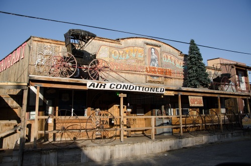
The Olive Oatman Restaurant and Saloon. The place to get ice cream and booze, in one trip.

Olive Oatman in 1863. Her fame was widespread at that time. The mine bearing her name was recorded around the time of this photograph. Wikipedia
Her likeness, which includes Mojave-face-tattoo highlights, is displayed on the façade of Olive Oatman Restaurant and Saloon on the eastern edge of the main street. The eatery serves sodas, chili and ice cream to sun-parched tourists during the season. A long banner above the porch boasts, “Air Conditioned.” Next to it is another sign that reads, “Open.” But, the eatery is not ready for the day, the business doors are locked. They are in fact, closed.
Across the street is the eight-room, Oatman Hotel. It was the honeymoon spot for actors Clark Gable and Carol Lombard when, in 1939, they eloped to Kingman 30 miles across the Black Mountains to the northeast. Stories are told of the couple’s secretive escape out of Hollywood in an effort to avoid the press of the day.

The Oatman (Durlin) Hotel was established one year before Olive Oatman’s death in 1903. Film stars, Carol Lombard and Clark Gable, shared their honeymoon here and were reported to have stayed here several times in their short tragic marriage.
Old timers told of card games with Gable into the late hours and his enjoyment of the townspeople that drew the couple back to the inn on numerous other occasions. Apparently he and Lombard didn’t mind the ghost who is said to haunt the place. The old establishment that they enjoyed has survived several disasters in the town’s history. But in 1921 the hotel and many of the surrounding buildings weren’t as lucky and were destroyed by fire. It was rebuilt in 1924. Some reports say that the adobe walls remained intact and were reused for the current structure.
As we pass through, the famous burros of Oatman are nowhere to be seen. We will find them later trotting between the rocks and clumps of sagebrush a short distance down the road. These locals were introduced to the region in the 1860s when gold was discovered. Some are descended from pack animals used by The California Volunteers, troopers who moved from the nearby post, Fort Mohave, to search for gold.

Burros are protected by the BLM. They think… or rather, know, you are on their turf.
Over time other “booms” of gold-hungry immigrants would lose or release animals. Today there are several hundred wild burros in the area that are protected by the Bureau of Land Management. Some are offered for adoption each year in the Bureaus’ Wild Horse and Burro Program.

The view from Sitgreaves Pass northwest through the Black Mountains.
Onward we drive, competing with the clock. The hairpin road seems to spiral as we climb. To the left, just before the summit, is the Gold Road Mine. It is currently under study for reopening, giving hope to the owners that they might soon take advantage of the rising price of gold. A few more turns and switchbacks we are on top of 3,550-foot-high Sitgreaves Pass. Stopping is a necessity to take in the view toward the northwest.
Three-hundred yards below us is a short, loop road. We had missed the dirt turnoff to a panorama site with views of the Mojave Valley, the Colorado River and California beyond. The site is covered with small crosses and monuments to the dead. The ground is too rocky for graves yet crosses and memorials dot hillside below the overlook. A local custom is to scatter ashes of loved ones at the site, usually due to a last request by those who passed and had loved the area.
I would love to study this Sitgreaves site, but we can’t turn around. Time on this leg of the trip is dominating our plans. A short photo op and again we are rolling past the sage, rocks, and sand. Thinking back, I had seen a similar cross-covered site a few weeks earlier above Cripple Creek, Colorado. There the cross-on-the-hill placement started on the prominent point after cars plunged over. Families would place memorials to those who died. Later, as on Sitgreaves, loved ones would scatter ashes because of the beautiful vista from the point. Both places pique one’s interests and suggest a need for learning more. Both bring on sadness.

Onward along Old Route 66 to Kingman, Phoenix and home.
On we drive – the clock commands us. Another visit will be planned and we will return to this place and to the town and the ice cream in Olive’s Oatman’s Restaurant. The history and the legends demand it of us. Plus, there are the burros.
© J Byous Company 2018, All rights reserved

I drove rt 66 from springfield Mo. to santa monica. I went alone because my friends couldn’t just take off on a road trip not knowing where they would sleep or when they would get home. Plus, to me driving is a zen thing and they get tired of riding. I got off 66 to go to the Grand canyon. It was Oct. I bought a bag of carrots in Flagstaff because I was hoping to take a mule ride and wanted to give my mule a treat, but they were all booked and I didn’t have a reservation. so I went on to Oatman looking for wild burros. I didn’t see any and forgot about the carrots. but when I pulled into Oatman the burros were there and they smelled the carrots. They came up to my car and I couldn’t get the windows up fast enough. they had their heads in my windows! There was burro snot all over my car! I got out and they ate the carrots so fast they almost ate the plastic bag too! It was so funny! I’ll never forget. I asked a man to take my picture with my camera and got a shot of me with a burro. That was back in the days before digital cameras.
I bought a huge skull of a bull in Oatman and it rode in my backseat for a few weeks till I got home because there wasn’t enough room in the trunk.
Thanks for your post reminding me of my adventure! The pix are beautiful! I remember the stillness of the desert and every day I cried tears of joy because it’s so beautiful.
LikeLike
That’s a great story, Chris. Our trip was a zip-through because of lodging as well. We were taking a side track to see relatives in Surprise, AZ. Thanks for sharing. I love it.
LikeLiked by 1 person